Vaughan, Ontario, CANADA – July 11, 2024 –Teledyne Geospatial announces Galaxy Edge, the newest generation of its award-winning Galaxy airborne lidar solution. Galaxy Edge delivers high-resolution data with the most efficient acquisition in steep terrain, resulting in lower carbon footprint and a 20-50% reduction in collection costs. The new Teledyne solution responds to market needs for uniform point density by accelerating the scan speed and delivering straight and parallel scan lines. It also optimizes for wire detection and reduces atmospheric noise and processing labor. Galaxy Edge is compatible with fixed wing, pressurized aircraft, drone or helicopter platforms. Real-time processing powered by Galaxy Onboard delivers lidar point clouds for immediate use upon landing.
Features and Benefits:
Galaxy Edge will power the latest electric utility solution, Network Surveyor which is designed specifically to meet the time constraints for electric utilities by combining unmatched lidar technology with edge processing to deliver actionable data in near real time. Galaxy Edge will extend Network Surveyor’s value by delivering uniform data cross right of ways, diminish manual labor in atmospheric noise filtering, and deliver analysis-ready data on landing.
"Our new Galaxy Edge reaffirms our dedication to developing long-endurance, highly robust airborne sensor technology. We deeply value our customers and their expressed needs for enhanced productivity, cost-effectiveness, reduced flying hours, lower carbon footprints, and higher data resolution,” said Malek Singer, Teledyne Geospatial’s Product Manager, Airborne. “While we certainly meet these needs, our true strength lies in delivering faster results. Many claim productivity, but none can quite match our terrain and turbulence compensation capabilities. Galaxy’s single-pass resolution outshines all other sensors by a significant margin. And most importantly, when it comes to fast processing, only Galaxy can truly deliver in real-time.”
Teledyne Geospatial unifies the hardware and software expertise of both Teledyne CARIS and Teledyne Optech. The new group provides customers with innovative integrated solutions. Offerings include turnkey systems, lidar and sonar integrated workflows and a range of systems and solutions that support holistic, precision data collection.
For media enquiries, please contact:
Jennifer Parham
[email protected]
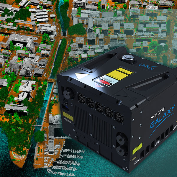
Galaxy Edge delivers parallel scanlines and higher resolution of smaller objects like electric wires, poles, and street signs