
This cutting-edge technology will enhance Topocart’s ability to map large urban and rural areas with high-density precision.
Tuesday - 30 July 2024
Vaughan, Ontario, CANADA – July 30, 2024– Teledyne Geospatial is pleased to announce that Topocart, a leading Brazilian company with over three decades of experience in high-precision mapping, has acquired a Teledyne Galaxy PRIME+ lidar system. This cutting-edge technology will enhance Topocart’s ability to map large urban and rural areas with high-density precision.
The Galaxy PRIME+ lidar system, recognized for its superior productivity compared to conventional fixed field of view sensors, features the innovative SwathTRAK technology. This allows for effective mapping in mountainous regions, at safe and stable altitudes, resulting in consistent coverage and minimal sidelap. “This technology guarantees successful coverage of a flight strip, regardless of terrain variations, resulting in uniform data across the mapped area,” says Eng. Givanildo Silva, Technical Director at Topocart.
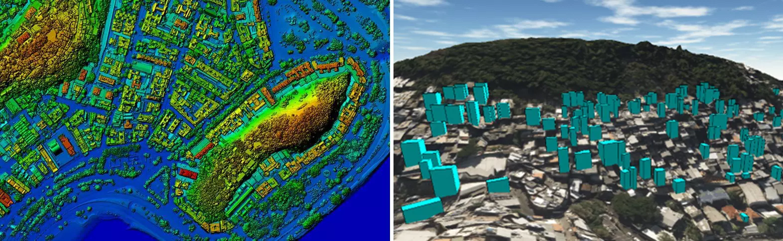
Left: Digital Surface Model of the city of Rio de Janeiro at 8 points/m²; Right: Image depicting newly constructed buildings identified in the 2023 lidar survey, contrasted with the survey from 2019
Topocart’s decision to acquire the Galaxy PRIME+ was driven by the need to conduct high-altitude flights at speeds exceeding 400 km/h, thereby covering a significant mapping area. The system was instrumental in mapping a part of the state of Bahia, an area of 32,000 km2 with terrain variations of up to 1,200 m. The Galaxy PRIME+ enabled simultaneous capture of photos and lidar data of the entire area, resulting in fewer flight hours, increased speed, and cost savings. Compared to a fixed field of view lidar system, Galaxy reduces the amount of flight lines, cost and carbon footprint by ~40%.
In urban projects, the Galaxy PRIME+ and Eagle Ultracam M2 system excelled in monitoring, regularizing and enforcing the unlicensed verticalization of buildings in Rio de Janeiro, a region known for its high air traffic. The system covered the entire project area of 1,200 km2 in just two takeoffs, collecting images with 15 cm GSD and Lidar data with a density of 8 points/m2. This data has been invaluable for the municipality’s urban planning, risk area identification, public works design, and urban growth control.
“We are delighted to supply our long-time partner, Topocart, with their first Galaxy PRIME+. We look forward to continuing our successful collaboration. The enhanced ranging performance and expanded range of motion provided by Galaxy PRIME's innovative SwathTRAK capability will significantly boost Topocart's collection efficiency," commented Juan Carballini, Sales Director
The partnership with Teledyne has propelled Topocart to new heights. The high-tech, easy-to-operate lidar sensor ensures cost optimization, superior quality final products, and faster response times for customers.
Jennifer Parham - [email protected]